
Drone & Aerial Services
Our licensed pilots use modern drones to capture 4k video, photography, and scanning services at stunning quality with fast turnaround.

Tell us about your professional media or project needs for a free evaluation and quote from our team today!
Quick answer
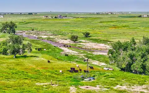
Land video production Denver, CO brokers use relies on drone footage, aerial photos, and boundary graphics to show acreage, access, terrain, and nearby development. Rocky Mountain Photography plans each flight around airspace, seasons, and what buyers need to understand about the parcel before they ever walk it.
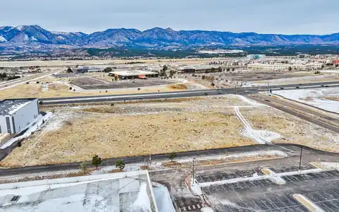
Raw land is hard to sell from the ground. A field or hillside looks the same as the one next to it until you see it from above with the property lines drawn in. That is why land parcel video in Denver, CO is now standard for brokers marketing infill lots, development ground, and rural acreage.
Our clients include land brokers, developers evaluating or selling sites, homebuilders, family landowners, and planners presenting projects to public boards.
A good parcel video opens high to show the region, then descends toward the property while boundary graphics appear. From there, it highlights access points, road frontage, utilities, slope, views, and neighboring uses that drive value, such as a new interchange, a school, or a growing retail corridor.
We create boundary overlays from survey files, plats, or county GIS data you provide, and we label them clearly as approximate unless a survey is supplied. Our property line drone page explains how those graphics are built.
Short edits of 60 to 90 seconds work well for listing sites, and a longer cut can support investor presentations.

Land changes with the seasons. Green spring and summer grass makes rural parcels look healthy, while bare winter ground can make infill sites look neglected. Snow can actually help define parcel edges on flat sites, so timing depends on the property.
Access is the other planning factor. Rural parcels may need four-wheel drive, landowner permission to cross neighboring property, or a gate code. Steep sites in the foothills need careful launch spots and attention to wind, which picks up quickly along the Front Range by late morning.
Before any land flight, our insured pilots with Part 107 certificates check airspace, which matters on the east side of the metro near Denver International Airport and around smaller airfields. For larger parcels needing measured outputs, LiDAR and mapping can add elevation data.

Brokers use land video to attract buyers outside Colorado. Developers use it in pitch decks and entitlement hearings, often alongside site plans. Builders use it to show lot positions in a new community, which overlaps with our housing development aerial page. Family landowners preparing an estate sale or a long-term lease often want a simple record of the property as it stands, which can be shared with relatives who live out of state. Lenders and appraisers sometimes request the same footage. Farm and ranch properties fit our agriculture photography page.
For polished edits with narration or text, see our land video production page.
Send the parcel address or coordinates, acreage, any survey or plat files, and your listing date. We reply with a written scope listing crew, deliverables, and timing, and you can book online once dates are set.




















Our licensed pilots use modern drones to capture 4k video, photography, and scanning services at stunning quality with fast turnaround.

We provide beautiful video & photography services to help our clients lease, sell, and market their properties and portfolios on time and budget

When you need a home captured in its best light to sell, showcase your work, or get attention in the marketplace turn first to our team of media pros.

Our brokerage has sold millions of dollars of commercial real estate across Colorado. Rocky Mountain Photography has been an excellent partner of ours, creating high quality professional media to showcase these various investment properties. They're consistently reliable, communicative and on-time.

Rocky Mountain Photography is a fantastic business! We used them for professional property photos for two of our commercial properties and were very satisfied with their work and help. They are very responsive, reasonable and talented. The pictures were exactly what we needed to effectively market our properties. Thank you to Jeff and his team for their help and excellent customer service!

Always do a fantastic job on my RE Listing photos and video. Great drone video and Twilight shots.

Super friendly and professional. Photos turned out great. Can't recommend highly enough.

Great service, quality, and speed. In addition to being a great photographer, Jeff is also a great guy to work with. Thanks again man!

“Great and thoroughly professional experience with the RMP Team. Quality, timeliness, delivery, and accounting were all best in class. Above and beyond service, can't wait to work with this team again.”

“Had an awesome time working with Rocky Mountain Photography on a shoot! Great communication through the whole process, excellent attention to detail. Would love to work with them again!”

“Rocky Mountain Photography is wonderful to work with! Jeff has been shooting my listings for over 4 years now and all my seller’s love his pictures. Jeff and Nick make a great team and are always flexible with my crazy schedule.”

“As a brokerage, we rely heavily on high-quality images to help sell multifamily and other commercial properties. RMP’s stunning photos have made a huge impact on our marketing efforts and have helped us to stand out in a crowded market. Their attention to detail and ability to capture the essence of each property is truly remarkable. They are responsive, professional, and always go above and beyond to ensure that the final product exceeds expectations.”

“Rocky Mountain Photography is wonderful to work with! They create so much value with their services. They are extremely knowledgeable with photos and video, and work hard to create compelling media that will take your business to the next level. What I especially love is the way they are able to draw out what makes your company unique, and bring that to the forefront with everything they do. They uphold and promote your brand. I recommend Rocky Mountain Photography without reservation!”
Fast, Reliable & Professional Aerial Photography, Video, Virtual Media & Custom Videos for the Real Estate & Construction Professional Across the World

Scheduling made simple. Use our user-friendly website for online booking or connect with project managers for personalized service—because your time matters

Time is of the essence! Count on us for next-day delivery, adding speed and excellence to your commercial, drone, and residential projects.

With coast to coast coverage, we offer professional nationwide drone, photo, and video coverage, capturing properties and projects wherever you need!

Customer satisfaction is at the core of our business philosophy at Rocky Mountain Photography. We’ll always go the extra mile to deliver exceptional quality and beautiful media for our clients.

Trust our video expertise for creating visually stunning service videos, credible testimonial videos, and tailored training video production to meet your needs.

Serving hundreds of businesses and thousands of clients, Rocky Mountain Photography is a trusted choice for exceptional photography, video, & drone services.

Our process begins with a detailed understanding of your project, followed by the assignment of a dedicated project manager. We then determine the ideal package to meet and exceed your media needs.

Once your project needs are understood, our team schedules and captures your photography, video, or drone media professionally from ground and sky, making sure to include all client specifications and instructions.

Upon completion, we meticulously edit and upload the media for your review, providing any necessary updates or revisions before sending the final high-resolution deliverables to you on time and on budget.
Typically an aerial video with parcel boundary graphics, labels for roads and nearby landmarks, high oblique stills from several angles, and views of access and frontage. Longer edits can add text callouts for zoning, utilities, and acreage that you provide.
Boundary graphics are based on the survey, plat, or GIS files you provide and are labeled approximate unless they come from a current survey. They help buyers understand the parcel shape but are not a substitute for a legal survey.
Some parcels near the airport are in controlled airspace that requires authorization, and a few areas may not be flyable. We check every site before quoting and tell you early if a flight is not realistic, so you can plan alternative views.
Late spring and summer usually show rural land at its greenest. For infill and development sites, any clear day without snow cover can work well. In some cases, light snow helps outline fields, so we talk through timing with you.
Yes. Developers use parcel aerials for investor decks, lender reports, and planning hearings. We can return at milestones as the site is graded and built so the same angles show progress from raw ground to finished community.
Send the address or coordinates, acreage, any survey or plat files, and your deadline. Our reply is a written scope naming the pilot, the boundary graphics, and when the parcel edit will be ready. Once the date is set, you can book online and share any gate codes.